Recent floods in Donegal: the challenges in forecasting extreme weather
Weather forecasts are based almost exclusively today on Numerical Weather Prediction (NWP) models, complex software packages that mimic the numerous processes that describe the physical and dynamical laws driving the weather. The complexity of the mathematical framework that describes these processes is such that the system cannot be explicitly solved; it can only be estimated by deploying a fictitious three dimensional grid overlaying the computer-simulated atmosphere and employing numerical methods to approximate the key weather elements at the mesh points (“grid-points”). The method may appear to be remote from actual weather but it is remarkable how well the current generation of NWP models perform; forecasts for a week ahead are usually accurate enough to be regarded as useful for planning weather-dependent activities.
Accuracy, however, is variable. Rainfall forecasts, particularly when the amounts fall into the category of extreme weather, are notoriously difficult to get a handle on and while the overall pattern may be forecastable for several days in advance, the specific details regarding location and amounts may be confined to much shorter intervals. In truth, all weather forecasts have the seeds of failure built in to the system: tiny errors in the initial description of the atmosphere grow – the “butterfly effect” - in a chaotic way and accuracy eventually nosedives as the forecast advances.
Rainfall forecasts are particularly prone to loss of accuracy for another reason: intense showers may only be a few kilometres in horizontal size so if the numerical mesh is not fine enough these may not be resolved by the model, or poorly approximated. Kilometre-scale mesh sizes are needed to catch the details, at significant computational cost, and even then some relevant processes may be missing from the model. Ultimately, the chaotic nature of weather will defeat attempts to pin down the exact timing, position and intensity of showers.
There is a further issue with model-predicted rainfall. The forecast amounts are not point forecasts, unlike say temperature; they are, loosely speaking, average values over a model mesh grid square. Even with a fine mesh of a few kilometres this averaging may miss local peaks in rainfall.
Weather on 22nd August 2017
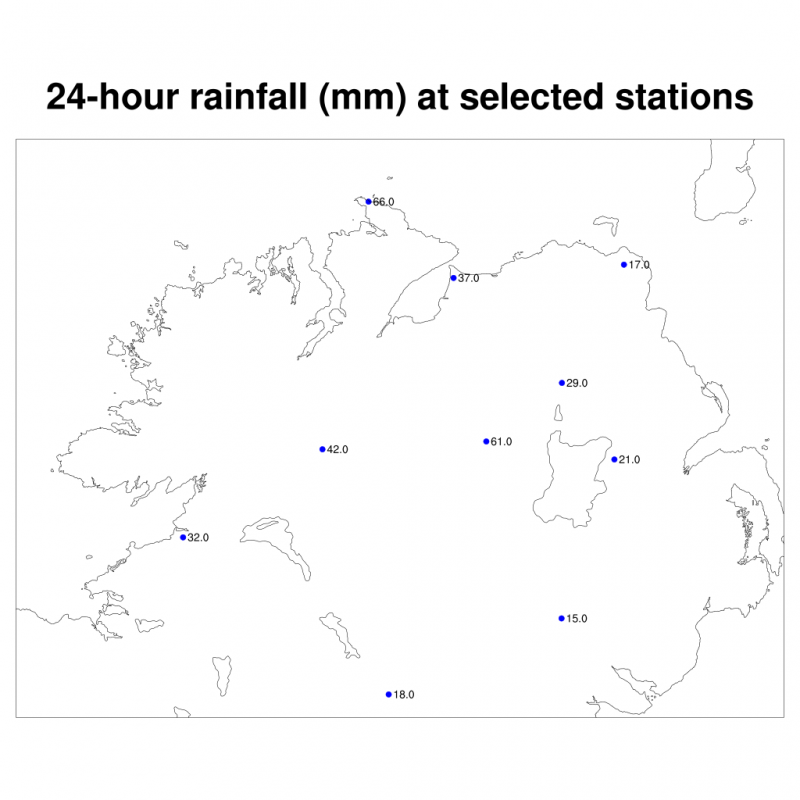
Figure1: 24-hour cumulative rainfall (mm) for selected stations for the period 06 UTC 22-23 August 2017
The heavy rainfall in Donegal and Northern Ireland caused major flooding damage for local communities. Figure 1 shows the provisional cumulative rainfall amounts for the 24-hour period ending at 06 UTC on the 23rd (07:00 local time) for selected observing stations. Notable falls were recorded at Malin Head (74 mm), Lough Fea (61 mm) and Castlederg (42 mm). However, much of the rain fell in the late afternoon, and particularly in the evening, associated with thunderstorms; in Malin Head approximately 60 mm of rainfall fell in the evening, 33 mm over a two hour period. Climate station observations, when they become available, are likely to reveal more substantial daily totals in the region but the hourly rainfall amounts in areas not covered by observations will remain unknown; in view of the widespread flooding in the Inishowen peninsula the local hourly values may have been considerably higher than those recorded at Malin Head.
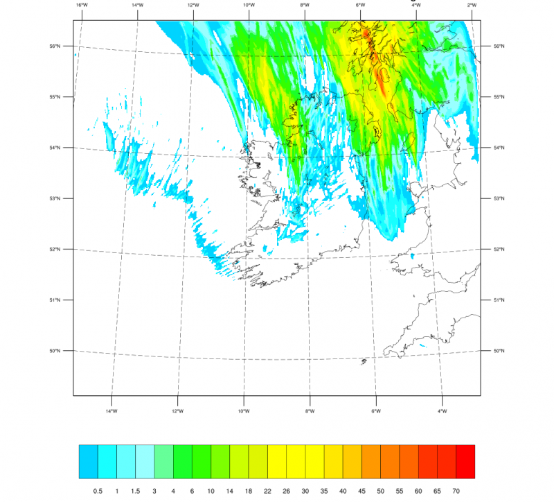
The satellite images in Figures 2 shows an unstable trough line following behind the cold front that crossed over the country during the afternoon. By 21/22 UTC this complex system had formed a line of intense convective showers stretching from County Down to the Inishowen peninsula, moving slowly northeastward but pivoting to some extent over the peninsula, clearing the country by about 01 UTC.
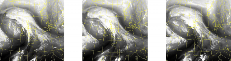
Figure 2: Satellite images (channel 6) for 18, 20, 22 (left to right). Copyright EUMESTAT, NERC Satellite Receiving Station, University of Dundee
Numerical Weather Forecasts
The reference operational ECMWF global forecast from 00UTC on the 22nd is shown in Figure 3 – the accumulated 24-hour predicted rainfall ending 06 UTC on the 23rd - for comparison with amounts listed in Figure 1. While the essential pattern is captured, local amounts were considerably under predicted, particularly in the Inishowen peninsula; maximum forecast amounts were 30-35 mm around Lough Neagh and surrounding counties but typically less than half those values over Inishowen. The hourly rainfall rates were also too low, peaking at about 10 mm/hour in the early evening (less over Inishowen). With a mesh resolution of about 9km, it is perhaps not surprising that the ECMWF model did not capture the full intensity of the rainfall. Later forecasts from ECMWF at 12 UTC on the 22nd showed similar patterns.

Figure 3: ECMWF 24-hour forecast cumulative rainfall for the period 06-06 UTC 22-23 August 2017. Forecast was launched from the 00 UTC analysis on the 22nd.
Can a finer model mesh do better? Figures 4-6 show the equivalent forecasts using the WRF limited-area model with a mesh size of 1.5 km. The operational global analysis data from the ECMWF model were used to provide boundary information for WRF. Two configurations were used: one in which the ECMWF model data were simply ‘downscaled’ by the WRF model, and in the second case a 3-hour data assimilation scheme (3DVAR) using conventional observations (surface and upper-air) was used; in both bases the simulations were launched from 00 UTC on the 21st.
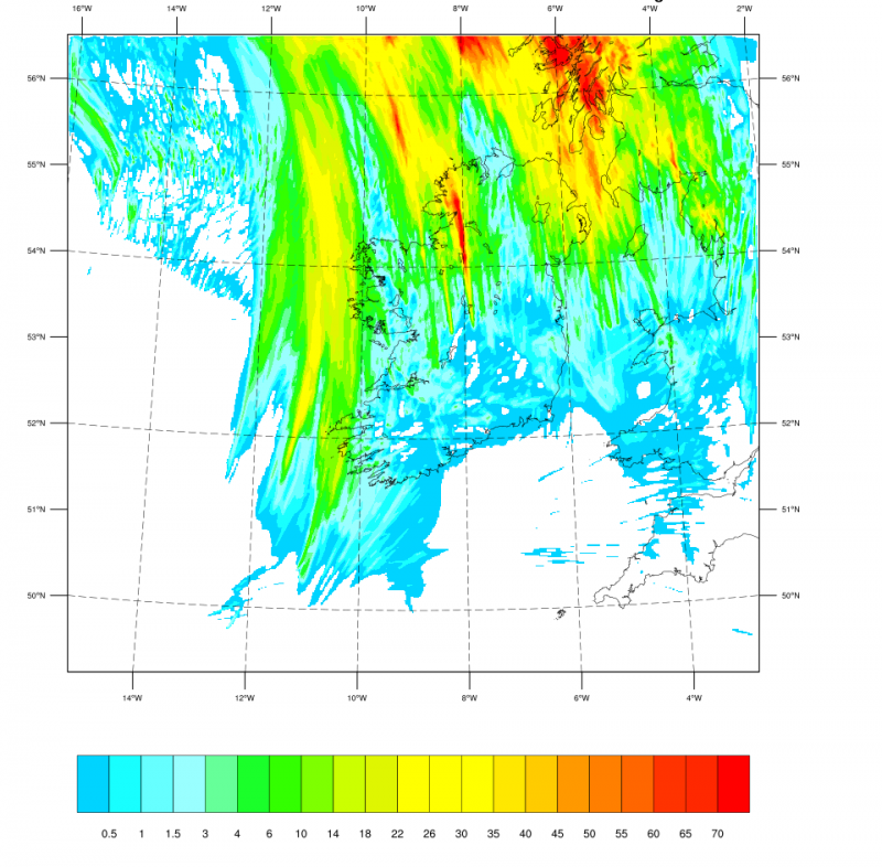
Figure 4: WRF downscaled 23-hour forecast cumulative rainfall for the period 06-06 UTC 22-23 August 2017
Figure 4 shows the accumulated 24-hour predicted rainfall ending 06 UTC on the 23rd, from the WRF downscaling forecast, which should be compared with Figures 3 and 1. It shows more intense rainfall compared to the ECMWF forecast: up to 75 mm over Donegal associated with the trough behind the main front but only 20-25 mm over Antrim and only a few mm over Inishowen.
Figure 5, showing the forecast rainfall accumulation during the evening of the 22nd i.e. a 6-hour period ending 00 UTC on the 23rd. The equivalent plot for the WRF version using a 3DVAR data assimilation cycle is shown in Figure 6; it is similar to Figure 5 but the simple 'downscaling' version performed better.
In both cases the forecast peak hourly rainfall rates in the evening were in the range 30-40 mm/hour.
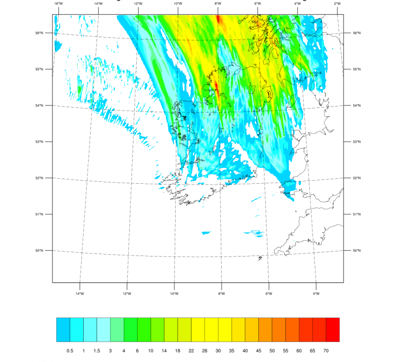
Figure 5: WRF downscaled 6-hour forecast cumulative rainfall for the period 18-00 UTC 22-23 August 2017
The WRF forecasts were run as 'hindcasts' to try to shed light on the ability of NWP models to capture the structure of extreme weather. Both configurations of the model performed better than the operational ECMWF model but neither configuration captured the intensity experienced over the Inishowen peninsula although the ‘downscaling’ version performed best and hinted at substantial rainfall over the area during the evening of the 22nd.
A more detailed investigation may shed further light on the event.
This research was carried out by ICHEC and UCD.
WRF simulations were carried out on ICHEC’s supercomputer.
Photo credit Donegal Daily @DonegalDaily