Earth Observation Images Indicate Evidence of Numerous Fires in Rural Mountain Areas During COVID-19 Shutdown
Satellite Data analysed by scientists from ICHEC (Irish Centre for High-End Computing) using European Space Agency (ESA)’s Sentinel 5-P satellite data shows evidence of Nitrogen Dioxide (NO2) emissions in a number of rural areas during February and March
Satellite Data analysed by scientists from ICHEC (Irish Centre for High-End Computing) using European Space Agency (ESA)’s Sentinel 5-P satellite data shows evidence of Nitrogen Dioxide (NO2) emissions in a number of rural areas during February and March 2020.
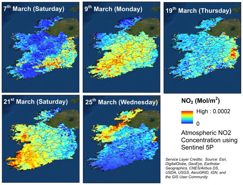
ICHEC released imagery today, Friday,3rd April in which the scientists observed general reductions in emissions (blue areas of the maps) from the lower levels of activity in the economy due to COVID-19 but also observed a few spikes (red areas) on some dates, most likely associated with fires in rural areas.
Alastair McKinstry, Environmental Programme Manager, ICEHC said, “ The data we looked at shows some overall reductions in levels of emissions in densely populated areas however, there are some spikes in Nitrogen Dioxide (NO2) emissions visible from the Cork and Kerry mountains on the 21st March, the Wicklow mountains on the 19th and 30th March, and the Comeragh Mountains also on the 21st March. As Nitrogen Dioxide (NO2) is a gas created from the burning of fossil fuels, it looks like these red areas are related to fires. Deliberately burning agricultural material is not only illegal but, given the fires in the Killarney National Park, in Co Kerry last weekend, is a drain on emergency services at a time when these services are already stretched, due to COVID-19”
Minister for Culture, Heritage and the Gaeltacht Josepha Madigan TD has condemned those who started a fire which led to the loss of 150 Acres of habitat in Killarney National Park as “reckless and irresponsible”. Wild fires are not a natural phenomenon in Ireland and can have a local impact on species that cannot escape, or that lose breeding habitat as a result.
Minister Madigan commented that, “As well as having severe localised impact on flora and fauna, setting fires during this time of National public health emergency is particularly reckless as it places unnecessary additional pressures on our emergency services as they valiantly tackle the current pandemic. I would appeal to members of the public to be conscious of the dangers posed by fire on open ground. Even planned and/or "controlled" burning can get out of hand very quickly, so it is critically important that every member of society realises the damage that can be caused to property, our precious natural heritage and, indeed, the health and welfare of family, neighbours and the wider community, and the responding emergency services”
Dr. Sita Karki, Earth Observation Computational Scientist, ICHEC said,
“European Space Agency (ESA)’s Sentinel 5-P Mission helps to observe Earth’s atmosphere for temporal and spatial changes and monitor air quality. The satellite was launched in October 2017 and the data is now made available via Sentinel-5P Pre-Operations Data Hub (https://s5phub.copernicus.eu/dhus/#/home). The primary objective of this mission is to perform atmospheric monitoring of various gases at high spatial-temporal resolution and facilitate climate monitoring as well as forecasting. One of the practical limitations we faced is that it acquires the images during the mid-afternoon and in order to capture the effect of the fire or any event that occurred during the late-afternoon, we have to wait for the scenes from the next day. In that case, the gases or the pollutants might have travelled or dispersed considerably. These maps show the concentration of NO2 (mol/m2) in the tropospheric column on various dates.”
ICHEC established and operates the national Satellite Platform for Ireland (SPÉir) which hosts satellite data from the EU Copernicus programme for use by the Irish public sector, academic and enterprise organisations. SPÉir provides free and open access to the pre-processed satellite data through data processing and high-performance computer services.