Revisiting the 1957 Windscale Nuclear Accident using Atmospheric Reanalysis data
“We have been asked to let you have a copy which will, I am sure, be of interest to your experts.”
So concluded the letter to the Irish Department of Foreign Affairs from the British Embassy, dated 14 November, 1957.
The copy referred to an attached report, Accident at Windscale No. 1 Pile, 10 October 1957, which had been presented to the UK Parliament on 6 November. The report detailed the events surrounding a fire in the Windscale nuclear processing plant in Cumbria that occurred 60 years ago this year, the heroic efforts by the staff to bring it under control and measures taken to protect the public in the surrounding area. The enigmatic reference in the letter to “experts” may have puzzled Irish officials – Ireland had no nuclear industry and earlier reports suggested the impacts were largely local; perhaps the letter was simply to reassure the Irish Government, that there was no need for concern regarding possible nuclear fallout from the accident over Ireland. Windscale, then under the United Kingdom Atomic Energy Authority, was used for the production of materials for nuclear weapons. Over a period roughly from the afternoon of the 10th to the afternoon of the 12th the fire released radioactive material into the atmosphere.
The report was notable on two counts: the speed at which it was produced and its reference to a separate “technical” report, from a Committee of Inquiry, which was “not in [the] national interest to publish”. It is unlikely the Irish Government of the day saw a copy of the latter. However, in 1988 the embargoed report was released, subsequently revised in 1989 and released as A Revised Transcript of the Proceedings of the Board of Inquiry into the Fire at Windscale Pile No. 1, October 1957. It contained much more technical detail on the event but not on the atmospheric dispersion of the radioactive emissions.
In its conclusion, the main report was quite emphatic:
“We are satisfied that it is in the highest degree unlikely that any harm has been done to the health of anybody.”
In making this assessment the meteorological conditions surrounding the event received rather scant mention with the focus solely on winds at the site although the complexity of the problem in tracking the dispersion of material emitted from the 120m tall chimney was alluded to:
“There may have been an inversion at a few hundred feet above ground level during part of the period … [winds] may not have been in the same direction as ground level.”
Rather surprisingly, there is no mention of the UK Met Office, then part of the Ministry of Defence, being consulted to assess the dispersion of the radioactivity (there was a “Meteorological Station” at the site); the main emphasis of the report was on local impacts.
However, there must have been some concern as to how far the radiation was dispersed as milk samples from the Isle of Man were analysed for radioactive contaminants. In reality, the complex weather pattern over the area and the lack of detailed knowledge of the 3D structure of the atmosphere at the time of the incident, precluded a full analysis. This lack of data may have contributed to the optimistic assessment that contamination was restricted to the local countryside. Later assessment showed that a wider area was affected and it is generally accepted today that some deaths in the UK and elsewhere in Europe were likely attributable, in a statistical sense, to the radiological release.
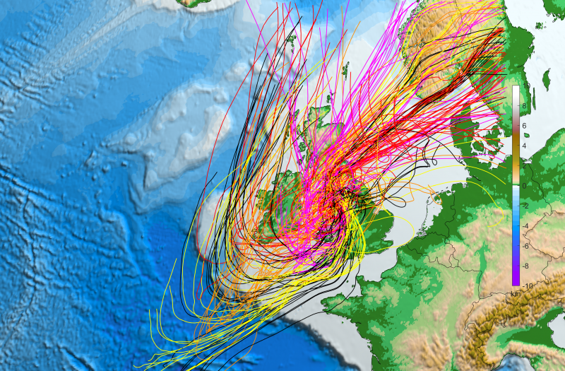
The weather and dispersion trajectories around the time of the Windscale (now named Sellafield) nuclear accident/fire as simulated by downscaled global reanalysis datasets using the WRF Numerical Weather Prediction (NWP) model at 6km spatial resolution. The left panel shows 100m wind speed (m/s) and MSLP (hPa) as simulated by the downscaled CERA-20C dataset; the right panel shows 5-day trajectories starting every hour from 10/10/1957 12UTC to 12/10/1957 12UTC; downscaled ECMWF ERA40 (black lines), ECMWF ERA-C20 (red), ECMWF CERA-20C (orange), NOAA 20th-Century Reanalysis (magenta) and NCEP-NCAR R1 Reanalysis (yellow).
The weather and dispersion trajectories around the time of the Windscale (now named Sellafield) nuclear accident/fire as simulated by downscaled global reanalysis datasets using the WRF Numerical Weather Prediction (NWP) model at 6km spatial resolution. The left panel shows hourly rainfall and MSLP (hPa) as simulated by the downscaled CERA-20C dataset; the right panel shows 5-day trajectories starting every hour from 10/10/1957 12UTC to 12/10/1957 12UTC; downscaled ECMWF ERA40 (black lines), ECMWF ERA-C20 (red), ECMWF CERA-20C (orange), NOAA 20th-Century Reanalysis (magenta) and NCEP-NCAR R1 Reanalysis (yellow).
Was Ireland affected?
Subjective assessment of the wind flow patterns at the time suggested that the fallout plume did not affect the country but may have travelled up the Irish Sea, close to the east coast of Ireland. In a 2005 research article, Gallagher et al. [1], found little evidence of radioactivity in lake sediments in Northern Ireland that could be attributed to the fire and concluded that it
“has had little or no impact of radiological significance on the northeast coast of Ireland and that any epidemiological clusters detected in the region are very unlikely to relate to radiation exposure from this event.”
This may not be true for other parts of Ireland. Atmospheric dispersion of contaminants can be quite subtle in complex weather situations, spreading widely over a few days, and while concentrations will be diluted in time by turbulence and diverging winds it is possible that rainfall washout may lead to local “hotspots” of deposition. Application of modern dispersion models can provide a detailed assessment of the dispersion pattern but these models require accurate data describing the 3D structure of the atmosphere, including not only wind but also weather elements such as temperature, humidity and precipitation. Unfortunately, computer weather models were in their infancy in the 1950s and such detailed weather information was not available at the time.
Recent atmospheric reanalysis projects, such as those undertaken by the European Centre for Medium-Range Weather Forecasts (ECMWF), have improved our knowledge of the weather around the time of the Windscale fire and led to new atmospheric datasets to facilitate a fresh look at the event. However, these global datasets typically have horizontal spatial resolutions of over 125 km which are rather coarse for a detailed regional analysis of the trajectories of the radiological emissions. To address this issue, the WRF numerical weather model was used to dynamically downscale the coarse global data and provide sharper estimates of the dispersion of contaminants.
As individual simulations of mid-20th century events are still subject to uncertainty, a number of reanalysis datasets were downscaled. Specifically, the WRF model was used to downscale the following five global reanalysis datasets (identified by colour in the animation loop):
- ECMWF ERA40 (black lines)
- ECMWF ERA-C20 (red)
- ECMWF CERA-20C (orange)
- NOAA 20th-Century Reanalysis (magenta)
- NCEP-NCAR R1 Reanalysis (yellow)
The simulations (run at 18km, 6km and 2km spatial resolution) were initialised at 00UTC on October 8th 1957 and ran for 11 days. A 5-day trajectory at ~114m height was calculated every hour from 10/10/1957 12UTC to 12/10/1957 12UTC. The animations above show the evolving weather and combined air parcel trajectories from the site based on the WRF 6km-resolution simulations; the 2km-resolution simulations gave similar results.
Initially, the trajectories moved east and southeast on the 10th, associated with slack winds, then turned south and southwest on the 11th, moving over Ireland on the 12th and 13th; the strengthening winds on the 14th brought the southerly trajectories over the southern and western parts of the country.
The results are not conclusive given the uncertainty in the emission details and the atmospheric data but are suggestive that some of the emitted radiation may have affected Ireland. A new atmospheric re-analysis dataset (ERA5 [2]), currently in production, should allow a more accurate assessment in the future.
The weather and dispersion trajectories around the time of the Windscale (now named Sellafield) nuclear accident/fire were simulated by downscaling five global reanalysis datasets using the WRF Numerical Weather Prediction (NWP) model at 6km spatial resolution. To track the fallout, 5-day trajectories were calculated every hour from 10/10/1957 12UTC to 12/10/1957 12UTC. The following five global datasets were downscaled; ECMWF ERA40, ECMWF ERA-C20, ECMWF CERA-20C, NOAA 20th-Century Reanalysis and NCEP-NCAR R1 Reanalysis. The animation shows the number of times a trajectory passes through a 12km x 12km square area.
Authors: Ray McGrath (UCD) and Paul Nolan (ICHEC). The research was carried out at ICHEC (as part of an EPA-funded climate modelling project) and UCD.
We acknowledge the support of Mairéad Treanor, Library and Archive Manager, Oireachtas Library & Research Service, in sourcing relevant archive documents.
[2] https://software.ecmwf.int/wiki/display/CKB/What+is+ERA5