Environmental Sciences Activity
ICHEC’s environmental activity represents a perfect example of the impact of combining technology and domain expertise.
The activity has three main strands:
- Next-gen technologies for advanced environmental weather and climate modelling
- Environmental modelling: weather and climate forecasting, Earth System modelling
- Earth Observation: data-centric knowledge discovery
ICHEC works with the public sector, academia and industry enabling their modeling needs: providing compute, data, and scientific and technical support to do modeling, forecasting and knowledge discovery.
In this we work with the Novel Technologies group, developing future weather models as part of the Horizon 2020 ESCAPE project, and handling petascale and Exascale data as part of the Horizon 2020 project ESiWACE.
We have worked with Met Éireann and the Hirlam community in developing the Harmonie model, used by Met Éireann operationally on ICHEC systems. This work has been funded by Intel as part of the IPCC collaboration. We work with Met Éireann also in the EC-Earth climate model.
We support Academic users across Ireland, including NUI Galway (for air pollution and volcano forecasting, model development); UCC and Maynooth University, as well as a long-standing collaboration with UCD in EC-Earth.
In Earth Observation, ICHEC works with the European Space Agency (ESA) and Enterprise Ireland to provide archival and access to Copernicus satellite data. For ESA, we provide the Environmental Validation Data Archive (EVDC). ICHEC also manages SPéir the Satellite platform for Ireland.
For commercial users, we provide compute facilities and data for modeling and forecasting, both Earth observation data and weather forecast data in collaboration with Met Éireann, with bespoke forecasts for the renewable energy industry.
Next-gen technologies for advanced forecasting & modelling
ICHEC has worked for nearly a decade in advancing weather forecasting and Earth System modelling (climate including land, Ocean and atmospheric modeling). Starting with a collaboration with Met Éireann on Hirlam and Harmonie, ICHEC has used its skills in novel technologies and accelerators such as the Xeon Phi, Nvidia GPUs and Xilinx FPGAs, optimising model performance.
As an Intel Parallel Computing Centre we have worked on testing and optimising the Harmonie weather model on Xeon Phi architectures, as well as the WaveWatch3 wave model.
We work within the Horizon 2020 project ESCAPE on scaling weather models to "Exascale", targeting the necessary energy performance needed to run forecasts at 1 km resolution.
Previous work has included work on the XIOS IO Server and OASIS3 Coupler. These are key components of the EC-Earth model used within Ireland, and this work within the PRACE consortium is an example of how such advanced technology development feeds back to improved modeling for public policy and safety.
For more information contact the activity lead Alastair McKinstry.
Environmental modelling for policy
Environmental sciences are key to a broad range of governmental and indeed international policies. From climate change and adaptation, to renewable energy, extreme weather events, public health, planning for land use, smart agriculture and many more. ICHEC’s modelling and domain expertise are leveraged to provide the necessary data to support the development of evidence-based policies in these domains.
Furthermore, the power of computer modelling allows to run “what ifs” scenarios far more quickly and cheaply than alternative methods of inquiries. This capability is proving particularly important, e.g., to test the effectiveness of various approaches at tackling scenarios such as how to best mitigate the impact of extreme weather events (e.g., by testing the impact of erecting flood defences at a particular site on downstream locations), or planning the location of renewable energy sites (e.g., by predicting the expected power output of wind/solar sites for specific locations and time periods).
The list of questions and scenarios for which ICHEC’s modelling capability can provide the necessary data to support evidence-based policies is comprehensive. And indeed to date ICHEC have already made numerous contributions, e.g., through reports such as Ireland's climate: the road ahead or Ensemble of regional climate model projections for Ireland as well as ICHEC’s contributions to the United Nationals Assessment reports 5 and 6 through the CMIP5 and 6 initiatives.
For further information, please contact the domain lead, Dr Paul Nolan
Data Centric Environmental Knowledge Discovery
The confluence of Open Data policy and Open Source Data Science technologies has created an opportunity for the application of Knowledge Discovery techniques to environmental problems.
Big Data and data science technologies in general are being driven by the needs of the social media industry and the corresponding Cloud based information technology services. These technologies are providing computing resources on demand, so that researchers are no longer constrained by available physical hardware.
Open Data is now a corner stone of government policy world wide, this is particularly true for environmental data. Open Data is data that is made available for unrestricted use. Open Data tends to be made available via data sharing portals, see figure below.
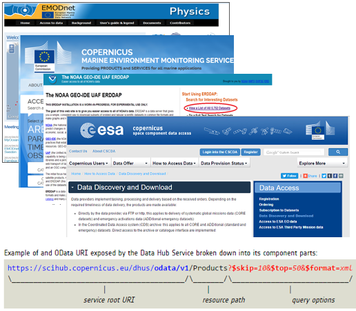
The challenge for environmental Knowledge Discovery is to combine these resources in a manner that is useful to environmental researchers. At ICHEC we are building infrastructure that allows for the consumption of environmental data via simple web services.
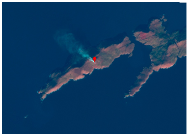
Earth Observation data from space are also covered by Open Data policy. The challenge for researchers is in how to manage and exploit the outputs from the various Earth observation programs. At ICHEC we are collecting Earth observations from the Sentinel series of satellites for the Irish geographic area (including the seas around Ireland) . In order to make the observations more accessible to researchers ICHEC is using its high performance computer facilities to calibrate satellite images and converting them to data formats that are familiar to the research community. In the example below we can see a fire burning on Dursey Island spotted by the Senintel-2 satellite.
For more information contact the activity lead Alastair McKinstry.